#
Assetic myData
#
Application Link
#
Link-Out from Pozi
Assetic myData is a Windows application that supports linking via a URL protocol handler.
For any selected asset feature, Pozi users can click a link to launch the myData application which displays the asset's details.
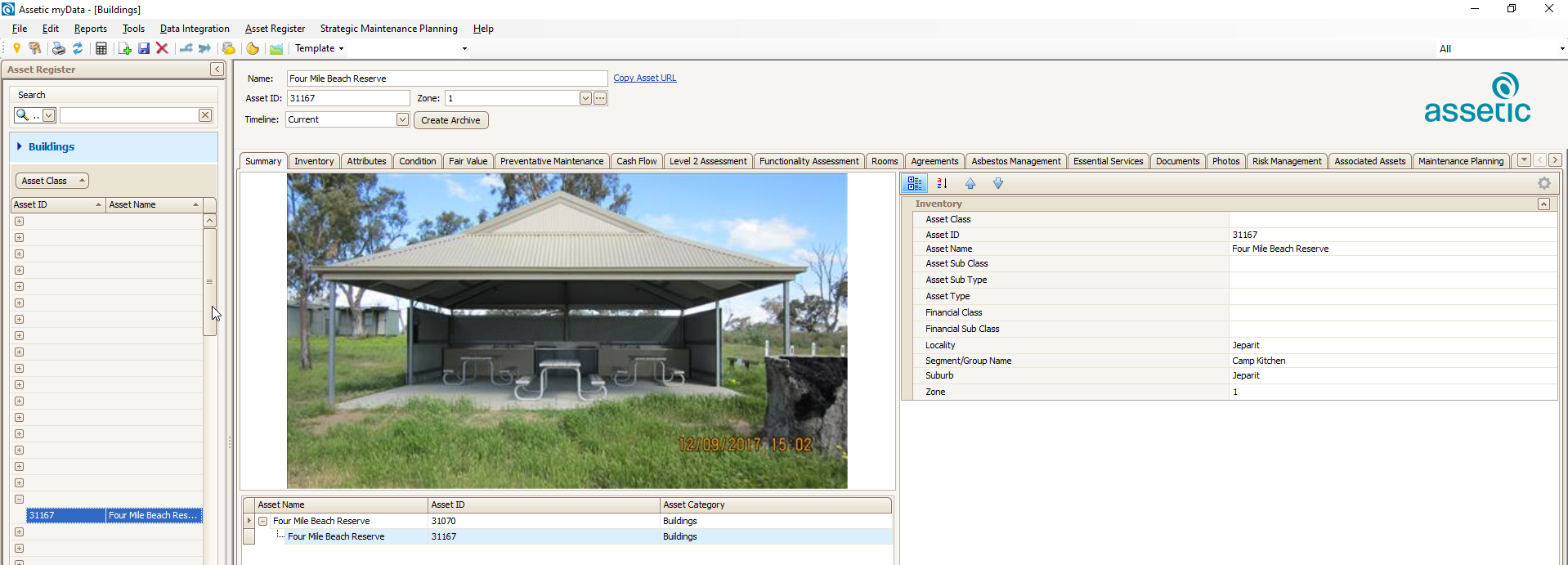
An example link for myData looks like this:
mydata://action=goto&assetCategory=Buildings&assetID=BD0021
For any PC on which a URL protocol handler has been installed, clicking this link will launch the myData application.
Layer Properties > Fields > Field Calculator > Create virtual field:
- Output field name:
Application Link - Output field type:
Text (string) - Expression:
'<a href="mydata://action=goto&assetCategory=Bridges&assetID='||Asset_ID||'" target="_blank" >Open in myData</a>'For more information, see the instructions for working with virtual fields.
The mydata protocol
Because the mydata URL prefix is a non-standard link, it is whitelisted within the Pozi application so that it can be displayed as a clickable link. If you're using the examples on this page as the basis for setting up a new protocol handler, contact Pozi Support to have it added to the Pozi whitelist.
An example configuration in the VRT file is as follows:
<?xml version="1.0" encoding="UTF-8"?>
<OGRVRTDataSource>
<OGRVRTLayer name="Buildings">
<SrcDataSource>\\nhillDB2\MapData\Assets\Building\Building.TAB</SrcDataSource>
<SrcSQL dialect="sqlite">
select
*,
'<a href="mydata://action=goto&assetCategory=Buildings&assetID=' || Asset_ID || '" target="_blank" >Open in myData</a>' as "Application Link"
from Building
</SrcSQL>
</OGRVRTLayer>
</OGRVRTDataSource>note
Some of the HTML link text characters (eg "<") require replacement codes (eg "<") to avoid breaking the XML format of the VRT file.
BuildingsBridgesCivilCulvertsDrainsFleetPlantAndEquipmentKerbsParkInfrastructureParksPathwaysPitsPlayEquipmentPlaygroundsRunwaysSealedRoadsStreetFurniture
#
Data Link
When a user selects an asset feature in the Pozi map, the feature's Asset_ID value can be used to look up details for that feature from a child dataset, such as a non-spatial table of asset, maintenance or inspection details.
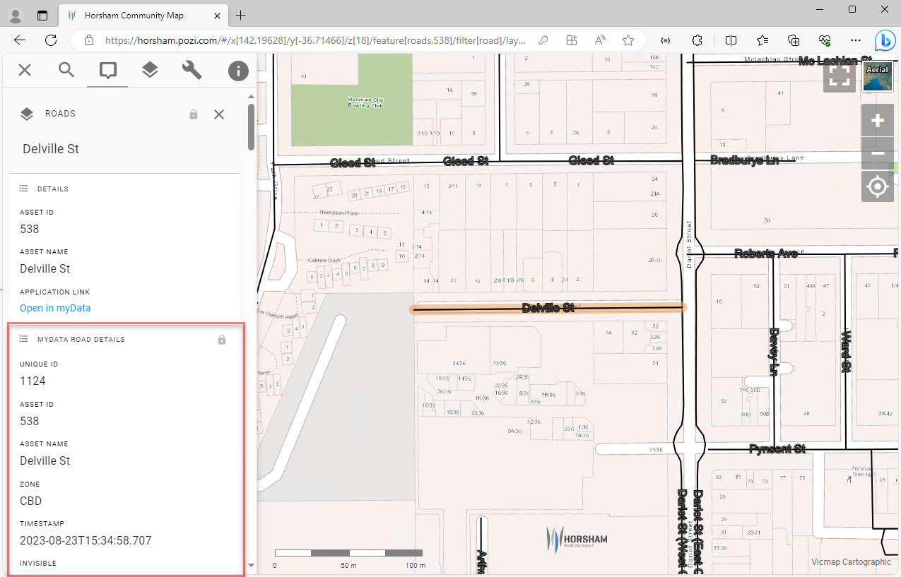
Add the non-spatial myData table to your QGIS project, enable it for WFS, and add the following keyword metadata:
Layer Properties > QGIS Server > Keyword list:
parent=Roads, parameter=EXP_FILTER=assetID in ('[Asset_ID]'), promoteDetails=trueAssumptions in this example:
- the parent spatial table is named
Roads - the id field in the parent spatial table is named
Asset_ID - the id field in the non-spatial myData table is named
assetID - if there is only one record per asset in the non-spatial table, it is useful to use
promoteDetails=trueto display the details automatically when the parent feature is selected
Adjust accordingly if your data differs.
For integrations that don't use QGIS Server, the parent-child data lookup can be added by Pozi Support within the site's configuration.
#
Site Configuration
{
  "title": "Footpath Inspections",
  "type": "GeoJSON",
  "parent": "Footpaths",
  "showInLayerControl": false,
  "localDataSource": true,
  "ResourceCheck": "https://local.pozi.com/resourcecheck/hindmarsh.json",
  "config": {
    "spatial": {
      "loader": "geojson",
      "url": "https://local.pozi.com/ogr?source=hsc_assets_inspections.vrt&options=-where|AssetID in ('[Asset_ID]')",
      "label": "InspectionNameAndDate",
      "id": "ID"
    }
  }
}
#
VRT Configuration
<?xml version="1.0" encoding="UTF-8"?>
<OGRVRTDataSource>
	<OGRVRTLayer name="Inspections">
		<SrcDataSource>ODBC:DRIVER={SQL Server};SERVER=NHILLDB2;DATABASE=myDataProduction,InspectionView</SrcDataSource>
		<SrcSQL dialect="sqlite">
		    select
			    *,
				InspectionName + ' (' + cast ( cast ( ScheduledDueDate as date ) as varchar ) + ')' as InspectionNameAndDate
			from InspectionView
			order by ScheduledDueDate desc
		</SrcSQL>
		<GeometryType>wkbNone</GeometryType>
	</OGRVRTLayer>
</OGRVRTDataSource>